

November 2023 Program Information
November 2023 Program
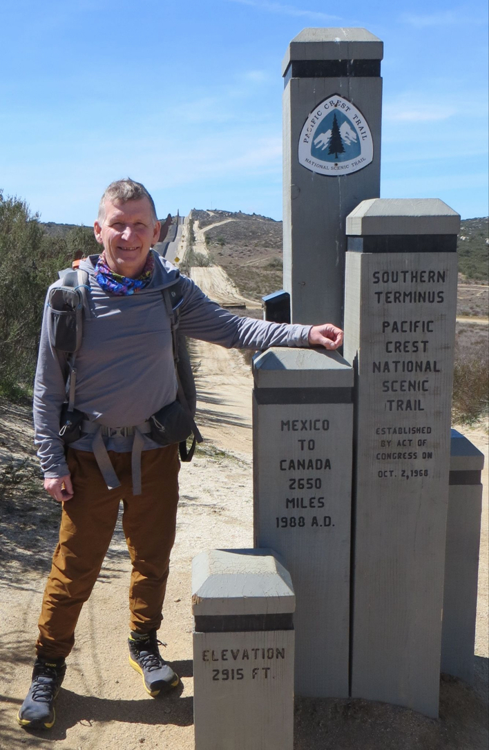
Scott Steele presented his program on hiking the Pacific Crest Trail in CA.He did several practice hikes with his dog, to the Laurel Highlands & Ohiopyle in PA, in the Black Mts of VT, Massanutten Peak, 100 miles in the Shenandoah Nat. Park and Table Rock in NC to name a few.
Scott hiked (alone) on two different trips - The first was from March 9 to April from Campo to Idyllwild on Mile 0 to Mile 152 going north from the border of Mexico/CA. The second was going south from the border of OR/CA in Ashland to Dunsmuir for 522 miles. He traveled from July 4 to September 1. The PCT covers 2653 miles from Mexico to WA, and 1300 of them are in CA. That's a lot of hiking! 🚶(The Appalachian Trail from GA to ME is 2190 miles)
He did a lot of research before going, and showed us some of the equipment he took. The equipment depends on the weather, the terrain, physical needs & safety. He wore a backpack 🎒 with about 40 lbs of weight with dehydrated food, camera, mini-Garmin -phone, rechargeable battery, tent, clothing, and the vital "Bear Canister" (required in some areas). An ice axe 🪓, trail poles, and umbrella added to the mix. He wore light-weight comfortable but sturdy hiking shoes🥾. He plans on carrying less gear on his next adventure. Backpacks get heavy quickly! He received supplies mailed from home, and in small towns along the way.
Reservations to hike the trail must be made approximately a year in advance and a long distance permit is required if hiking over 500 miles. Only 50 permits a day are allowed and there are many international hikers vying for them. Most hikers want dates within a "bubble" period, when the weather is better. Permits for distances shorter than 500 miles are more difficult to arrange. Reservations to spend the night in local towns (villages) must be made as well. These locations have few places to stay, and book up fast because many workers use them. (people who are constructing bridges, clearing trails, cleaning up after forest fires, etc) Plane reservations to an area close to start/finish is sometimes a challenge to book as well. Scott used local permits on the trip north, and a long distance permit going south.
Scott shared a few new terms with us: "Trail Angels" 👼 are linked to FaceBook and give rides from/to trails from small local towns. "Trail Magic" are areas on the trail that have a cache of water, snacks, tents, etc. A "bounce box" is a box that is sent from one town to another on your trip that may have your extra clothes, toiletries, etc that may be too cumbersome for the backpack. "Post-holing" referred to walking through layers of perhaps 4' deep snow and having to step in someone else's solid packed footprints. If not, the soft snow would give way, and a person would not be able to get out. "Blow downs" are trees that must be climbed over.
Scott traveled through varied terrain and ecosystems. Some trails were dirt & gravel, while many involved climbing -carefully- over rough boulders. 🪨 Many were very steep and narrow paths on the edge of cliffs, while others were well worn through meadows. He was saddened by the acres of burned areas where the trees were tall stalks with branches that could fall in an instant. In the burned areas, some trees had been sawed to allow passage, but others had to be climbed over. Trails are not marked, so a detailed map is a must. The use of a mini-Garmin phone is a necessity. 📱Elevation changes were dramatic throughout the trail - Palm Springs is below sea level, while Idyllwild was over 7000'. Hiking in thin air is challenging. Some areas were like deserts 🏜️, while others were lush with vegetation 🌲. He did see lots of types of granite. Scott collected a few rocks that he mailed home - it's tempting to gather a lot, but not when hiking 500 miles!
The weather must be taken into account. A month before he left, CA was having a lot of atmospheric rivers. Areas that normally would be dry, were flooded. He once had to wade through 4' of water. Sometimes he would remove his shoes, but other times, he just let them get soaked. Once, there was a cold rain that soaked him and his tent ⛺, not to mention the howling wind. He luckily met 2 hikers who allowed him to share a shelter, but he could not stop shaking. One of them was an EMT and said that he'd be ok in spite of the 8" of snow ❄️on the ground the next morning! Searching for potable water can become difficult at times. Water is heavy, so only a limited amount can be carried. Streams provide water, and trail hikers help each other find the liquid gold.
Here are some of the places Scott traveled to or saw. (Check them out online)
• From his first trip going north which took about a month:
⁃ Mt. Laguna
⁃ Anza-Borrego Desert State Park
⁃ San Jacinto
• These are from his 2-month trip going south:
⁃ Mt. Shasta 🏔️ was in sight for a long time
⁃ Seiad Valley
⁃ Klamath River
⁃ Man Eaten Lake
⁃ Russian Wilderness
⁃ Smith Lake
⁃ Jackson Lake
⁃ Klamath Mt
⁃ Mosquito Lake
⁃ Castle Crags
⁃ Burney
⁃ Hat Creek Rim
⁃ Lassen Volcano National Park w/a 1300' long lava tube
⁃ Upper Twin Lake
⁃ Boiling Springs Lake
⁃ Tamarack Lake
⁃ Sierra Buttes
⁃ Sierra City
Scott displayed some of the trail guides he used, and several "Story Behind" books that are sold in National Parks. He also had Geological Gems of California State Parks.
THANK YOU SO MUCH FOR SHARING THESE AMAZING HIKES WITH US!! YOU ARE BLESSED TO BE ABLE TO GO AND SURVIVE THE CHALLENGES OF THE TRAIL!
For more info go to this website: https://www.fs.usda.gov/detail/pct/home/?cid=stelprdb5304733